You can sponsor this page

Harpadon microchir Günther, 1878

Masukkan pemerhatian anda di Fish Watcher
Native range | All suitable habitat | Point map | Year 2050
This map was computer-generated and has not yet been reviewed.
Harpadon microchir   AquaMaps   Data sources: GBIF OBIS
muatnaik fotos/gambar dan video
Pictures | imej Google
Image of Harpadon microchir
Harpadon microchir
Picture by Reyes, R.B.


Indonesia country information

Common names: [No common name]
Occurrence: native
Salinity: marine
Abundance: | Ref:
Importance: | Ref:
Aquaculture: | Ref:
Regulations: | Ref:
Uses: no uses
Comments: From southwest Sumatra to Bali Strait. Museum: BMNH 1984.1.1.30 (PJPW133).
National Checklist:
Country Information: https://www.cia.gov/library/publications/resources/the-world-factbook/geos/id.html
National Fisheries Authority:
Occurrences: Occurrences Point map
Main Ref: Gloerfelt-Tarp, T. and P.J. Kailola, 1984
National Database:

Common names from other countries

klasifikasi / Names Nama-nama umum | Sinonim (persamaan) | Catalog of Fishes(Marga, Jenis) | ITIS | CoL | WoRMS | Cloffa

> Aulopiformes (Grinners) > Synodontidae (Lizardfishes) > Harpadontinae
Etymology: Harpadon: Greek, arpedon, -es = net, bow, knot (Ref. 45335).
  More on author: Günther.

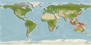
Environment: milieu / climate zone / depth range / distribution range Ekologi


Warning: mysqli::__construct(): (08004/1040): Too many connections in /var/www/html/includes/func_getlabel.php on line 46
Can't connect to MySQL database (fbapp). Errorcode: Too many connections