You can sponsor this page

Artediellus atlanticus Jordan & Evermann, 1898

Atlantic hookear sculpin
Adicionar as suas observações no Fish Watcher
Native range | All suitable habitat | Point map | Year 2050
This map was computer-generated and has not yet been reviewed.
Artediellus atlanticus   AquaMaps   Data sources: GBIF OBIS
Adicionar o seu Fotografias e vídeos
Pictures | Imagem do Google
Image of Artediellus atlanticus (Atlantic hookear sculpin)
Artediellus atlanticus
Male picture by Byrkjedal, I.


Greenland country information

Common names: [No common name]
Occurrence: native
Salinity: marine
Abundance: | Ref:
Importance: | Ref:
Aquaculture: | Ref:
Regulations: | Ref:
Uses: no uses
Comments: Occurs in the waters along the west coast from Holsteinsborg to Thule (77½°N). In East Greenland it occurs north of Jameson Land and occasionally in Denmarks Strait (Ref. 9926). Also Ref. 9925.
National Checklist:
Country Information: https://www.cia.gov/library/publications/resources/the-world-factbook/geos/gl.html
National Fisheries Authority:
Occurrences: Occurrences Point map
Main Ref: Fedorov, V.V., 1986
National Database:

Common names from other countries

Classificação / Names Nomes comuns | Sinónimos | Catalog of Fishes(Género, Espécies) | ITIS | CoL | WoRMS | Cloffa

> Perciformes/Cottoidei (Sculpins) > Cottidae (Sculpins)
Etymology: Artediellus: Petrus (Peter) Artedi, (10 Mar.) 1705-35 (28 Sep.), a son of a clergyman from Anundsjö named Olaus Arctaedius, in the northern part of Sweden.In 1729 he changed his name from Arctaedius to Arctædi, a name still later simplified to Artedi (Ref. 45335).
  More on authors: Jordan & Evermann.

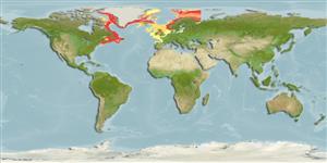
Environment: milieu / climate zone / depth range / distribution range Ecologia


Warning: mysqli::__construct(): (HY000/1040): Too many connections in /var/www/html/includes/func_getlabel.php on line 46
Can't connect to MySQL database (fbapp). Errorcode: Too many connections